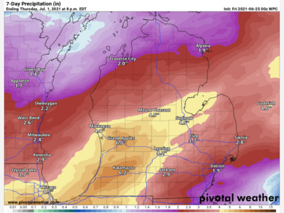
Image

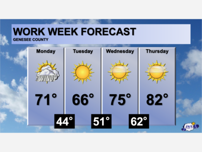
The weather forecast according to the National Weather Service for the start of the work week will start off a bit wet, but clear up later bringing sun albeit with cooler temperatures than last week.
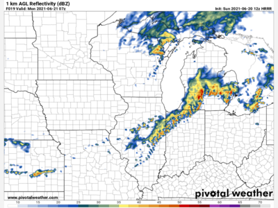
The forecast for the calls for showers off and on early Monday through Tuesday with a mix of clouds. Rain will start again after 2 a.m. Monday before subsiding by 8 a.m. and picking back up around 2 p.m. The early Monday low is expected to drop to 46 degrees with a south by south east wind of five to nine m.p.h. After daybreak expect mostly cloudy skies and highs reaching 63 by early afternoon. Light rain showers once again after 2 p.m. will once again dominate mid-Michigan with a chance of rain at 60 percent.
Monday evening showers are expected to taper off before 8 p.m., yielding to mostly cloudy skies and lows around 44 degrees with a west wind of around nine m.p.h.
Early Tuesday clouds will dominate to start followed by gradual clearing to some sun and a high near 60 degrees and breezes typically around 10 m.p.h., and gusts to 20. Tuesday evening will be partly cloudy and lows early Wednesday dropping to 39 degrees and mostly calm wind.
For Wednesday highs in the mid-50s and partly sunny. Thursday and Friday will continue with mostly sunny skies with highs in the upper 50s and lows near 40.

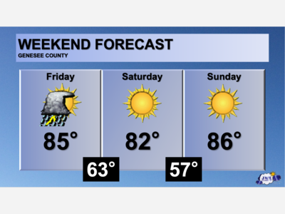
Patchy rain nearby, with a high of 86 and low of 64 degrees. Cloudy in the morning, sunny in the afternoon, patchy rain nearby for the evening, mist overnight.