Image

By Joel Robinson
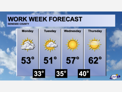
We’re in for a quiet stretch of weather this week, but here is a detailed look at what’s ahead!
Monday: Mostly cloudy skies with high temperatures in the low 50’s. Winds will favor from the west-northwest at 5-15 mph.
Tuesday: Cover your plants! Clearing skies and calm winds overnight will allow for temperatures to cool into the lower 30’s which could lead to areas of frost. More clouds will build throughout the day with temperatures heading for the lower 50’s once again. Dry with limited rain chances in the afternoon and evening.
Wednesday: High pressure will take over the Great Lakes region which will bring in a batch of sunshine and slightly warmer temperatures in the upper 50’s. Overnight low temperatures in the low 40’s, ridding the threat of frost.
Thursday: A copy and paste of Wednesday with a few clouds added and temperatures increasing to the low 60’s.
A warming trend will continue into the weekend as temperatures stair-step through the 60’s and into the 70’s by Sunday.

Patchy rain nearby, with a high of 86 and low of 64 degrees. Cloudy in the morning, sunny in the afternoon, patchy rain nearby in the evening, mist overnight.