Image

It is the best of Spring weather, and the worst of Spring weather. First, the worst.
If Mother Nature were a baseball pitcher, her very special pitch would be named Ole’ Man Winter. And it would be a nasty combination of a slider and curve that always lands on the corner for strike three. Tuesday, Mid-Michigan will get that nasty pitch and Mother Nature gets the last say on when winter ends.
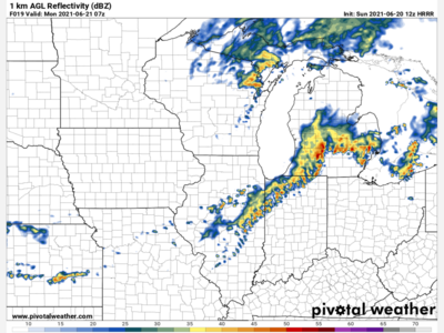
The Tuesday forecast calls for a decent, yet cold start. For the workday Tuesday, it will be partly sunny and 42. Snow yes SNOW will occur during the evening commute around 5 p.m., picking up after 8 p.m. with a low around 27 and winds out of the North at 7 m.p.h. Some parts of the area could receive as much as four inches of the white stuff, though much is not expected to stick due to the Spring warming of the ground.
Wednesday is expected to be Mostly sunny with a high struggling to reach 42 degrees and a North wind at 10 m.p.h., and gusts to 20.
Wednesday night will be partly cloudy with a low of 26 and a continued Northwest wind of five to 10 m.p.h., gusts to 18.
Thursday will begin the warm up. The high is expected near 53 and mostly sunny and once again a Northwest wind of 10 to 12 m.p.h. And gusts to a blustery 25. Thursday night will be clear with a low of 36.
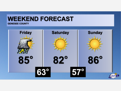
Friday will be mostly sunny and 63, ushering in a great getaway weekend forecast and a fine end to the work week.

Patchy rain nearby, with a high of 86 and low of 64 degrees. Cloudy in the morning, sunny in the afternoon, patchy rain nearby for the evening, mist overnight.