Image

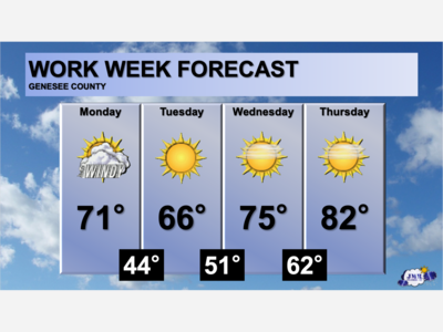
Your Work Week Weather from the Sentinel according to the National Weather Service is calling for a warmup beginning late Monday evening and early Tuesday with highs reaching the 80s Tuesday.
For the start Monday, however, it will be a bit chillier with morning temps starting in the low 30s and progressing to a mostly cloudy day with temperatures in the mid 50s, and a slight chance of showers after 2pm, and a Southeast around 8 m.p.h. For Monday evening, mostly cloudy, and a low around 45, with Southeast winds around 12 m.p.h and gusts as high as 21 m.p.h.
Tuesday will be partly sunny, with a high around 81, and a Southwest wind around 10 and gusts again reaching 21 m.p.h.
Tuesday night, their forecast calls for a chance of showers overnight and into early Wednesday, otherwise mostly cloudy, with a summer like low around 61 and winds again from the Southwest around 7 m.p.h., and a chance of precipitation of 30 percent.
Wednesday will bring showers and the occasional thunderstorm, otherwise it will be mostly cloudy, with a high near 77 degrees and a Southwest wind around 10 m.p.h., with gusts in the mid 20 range.
Wednesday night, showers will continue before giving way to mostly cloudy skies early Thursday and a low dropping into the low 50s again as showers give way to mostly cloudy skies early Thursday.
Thursday will continue a mix of light showers and mostly cloudy skies with highs near 63
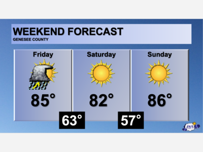
Friday will be mostly sunny, with a high near 59 and breezy.

Patchy rain nearby, with a high of 86 and low of 64 degrees. Cloudy in the morning, sunny in the afternoon, patchy rain nearby in the evening, mist overnight.